Where They Lived – Thomas Neill, Agnes Feran and their Children
Background
The question of where the Neils lived is, naturally, connected to how and when they came to be in the Gorbals parish of Glasgow where records show most of the family – perhaps all of the family – lived. I do not have any documented addresses for Thomas Neil or any census return which records him so I do I know his place of birth either. The first recorded address I have for this family is for his wife, Agnes Feran, at the 1841 Census where the record says that she was born in Ireland. It is possible that Thomas was also born in Ireland though he could as easily have been born in Glasgow or migrated to Glasgow from somewhere else in Scotland – possibly the highlands or the lowlands, both of which shed large numbers of people as farming became mechanised and rationalised leading to fewer jobs at the same time as work opportunities grew in the cities. I discuss this issue elsewhere.
At the 1841 Census Agnes Feren and two of her children, Charles (14) and John (4) McNeil (sic) are living at Muirhead Street, Gorbals; the boys are said to have been born in Lanarkshire. At the same census but living at St Ninian, also in Gorbals parish, was Elizabeth Neal (sic), sister to Charles and John. She is aged 20 and is living in the household of a Mrs Rogan, “lodging keeper”. Also living there is Daniel Wilkie who married Elizabeth on 31 December 1840 (it is unclear why she is recorded as a Neal not a Wilkie) She and Daniel are both recorded as having been born in Ireland.
Ten years later, at the 1851 Census, Elizabeth is recorded as being Elizabeth Wilkie and she lives with and her husband, Daniel, and their three children, William (10), James (4) and Elizabeth (2). They live at 85 Main Street, Gorbals. Also in their household are her brother, John McNeil (15) and sister, Agnes McNeil, (26). There is also a James McNeil but I do not know yet if he is related since he is described as being a “lodger” rather than a “brother-in-law” of Daniel as John is. Unlike the 1841 Census, Daniel and Elizabeth are said have been born in Glasgow as are all the members of the household. I know of one other child to Thomas and Agnes and that is Patrick who was baptised in Glasgow 12 August 1833.
I feel that the 1851 Census is more reliable source for a place of birth for Elizabeth than the 1841 Census. At the former the information is probably given by her or her husband but at the 1841 Census it is more likely provided by the lodging-keeper. For now I make the assumption that all Thomas and Agnes’s known children born between 1819 and 1836 were born in Glasgow.
Because I do not have any specific addresses for any of the family before the 1841 census I cannot be sure that the children were all born in Gorbals parish but, since the later events in the lives of these children do show them living there, tit is a distinct possibility. So what was the Gorbals like during the first half of the 19th Century? In the following sections I firstly outline some of the history of the development of the different areas south of the river and then, secondly, concentrate more on the small parish of Gorbals and the streets where they lived.
Glasgow, Govan and Gorbals – Some Early History
John Ord, in “The Story of the Barony of Gorbals” writes of Gorbals or Bridgeend / Brigend as it was originally known:
During the Middle Ages, the lands belonging to the Barony and Regality of Glasgow were divided into four wards. Of these, Govan ward covered an extensive area on both sides of the Clyde, and was subdivided into ten smaller sections for purposes of letting, feuing and subletting. The five sections on the south side of the river were Little Govan; Gorbals; Titwood and Sheills; West Sheills; and Meikle Govan…. During the fifteenth and sixteenth centuries the village of Brigend was celebrated for the manufacture of swords and ‘harquebuses’ (handguns), which were said to be among the finest in Europe. Some vestiges of this industry remained right through to the early nineteenth century, when the only gun makers in western Scotland were to be found in Gorbals…
From the sixteenth century, the section called Gorbals was let, and subsequently feued, as one holding until it was sold to the city in 1650.
In pre-reformation times Gorbals had come under the authority of the Bishops of Glasgow. After the Reformation, the church feued the village and lands of Gorbals for ground rent to Sir George Elphinstone, merchant and provost of Glasgow. In 1636 the land was sold to Robert, Viscount Belhaven who failed to make a financial success of it, so in 1650 he sold the lands of Gorbals to the City of Glasgow “to be held by them—one-fourth for behoof of the city, two-fourths for behoof of Hutcheson’s Hospital, and one-fourth for behoof of the Trades’ Hospital”.
In “The Gorbals an Illustrated History“, Eric Eunston writes:
There were no merchants in the village during the first half of the seventeenth century, and its inhabitants were debarred from many areas of manufacturing by the rules of the trades’ guilds of neighbouring Glasgow. However, after 1650 agreements were eventually reached between the guilds and the artisans of Brigend, permitting the villagers to become weavers, skinners and wrights. In 1655 the Town Council loaned the sum of 2,000 merks (approximately £111 sterling) to Patrick Bryce and James Anderson, for working coal pits in Gorbals for a term of thirteen years. The location of these mines remains unknown, but they may have lain near the southern extremity of the barony in what is now Govanhill, where coal mining continued well into the nineteenth century.
In the “Old Statistical Account of the Parish Gorbals OSA Vol 5 1793” the Rev. Mr William Anderson writes:
The air in the Gorbals is rather moist, and the terrain is flat with a very small rise for some miles; the diseases are consumptions and fevers, tending to putrid. The tide rises several miles above the area, at times forcing back the river water, which occasionally tastes salty or brackish.
The village and lands near the river are subject to inundation, but they are seldom great. There have been two remarkable floods, however, in the years 1712 and 1782. On March 12, 1782, boats might have sailed through many streets in Gorbals, as they really did on that occasion in the Bridgegate of Glasgow. The whole ground appeared sea for a mile west, and about an eighth of a mile from the river, a small island appearing about the fourth end of the church, and the field west from it.
Reverend Anderson goes on to comment of the growth of Gorbals through the 18th century:
At the start of the century, the village consisted only of a few thatched houses on each side of the great road from the south end of the old bridge. These were mostly possessed by maltmen, who made malt and brewed ale. In the year 1730 it was much increased, and the intermediate spaces betwixt the old houses being filled up with houses occupied by weavers.
In the (year) 1732, the present church was built, as a Chapel of Ease to Govan. In the year 1748, the greatest part of the village was burnt, after which it rapidly increased. The houses built were good, some of them consisting of 2, and others of 3 stories and garrets. In 1771, the village was computed to contain 3000 persons, besides 500 more connected quoad sacra. The village at present consists of upwards of 5000 souls, besides about 800 who are joined connected quoad sacra. Within three years, it is expected, the number will be doubled, and in 20 years a new Glasgow will probably be raised on the south side of the Clyde…It is impossible to ascertain either the births or burials precisely, as the inhabitants of Glasgow both baptise and bury in the Gorbals, and those of Gorbals in the city. There are some 200 baptisms in the year. The people are industrious; there are several reputable manufacturers, and a good many good operative weavers; there are 556 looms, besides a number of gunsmiths, nailers, shoemakers, tailors, wrights, cotton spinners etc.. There are also 60 public houses, which hurt the morals of the people not a little. Many of the inhabitants live to a great age. There are several of 70, 80, and 90, some have been known to live to 100 and 104
John McArthur’s 1778 “Plan of the City of Glasgow” shows ‘Gorbells’ as still a relatively small village with a burial ground situated a little outside of the village and otherwise surrounded by fields. In his book “The Gorbals an Illustrated History” Eric Eunson describes it as “a few streets and a disordered clutter of buildings arranged along lanes with vennels between them“.
As the century progressed, Gorbals grew. The Reverend Anderson commented on the situation in 1793:
“The barony of Gorbals is begun to be feued. There are plans for new streets on the east and west of the old village, which, at a moderate computation, will contain upwards of 50,000 inhabitants. The feuing goes on briskly, there are upwards of 120 steadings already feued, and begun to build on.”
Here the reverend is referring to the above-mentioned division of the Gorbals lands “to be held by them—one-fourth for behoof of the city, two-fourths for behoof of Hutcheson’s Hospital, and one-fourth for behoof of the Trades’ Hospital” which was made law in 1650 but which was not formalised until 1790. This arrangement meant that the rents for the Gorbals lands were to be paid to three beneficiaries, namely the Glasgow Council, the Trades House and Hutchesons’ Hospital. Glasgow Council took responsibility for Gorbals village itself and the lands lying to the south of it while the other two institutions established new suburbs in the eponymously named Hutchesontown and Tradeston. In “Glasgow, Mapping the City” John Moore writes:
“The Tradeston scheme of eight blocks was laid out, between 1790 and 1798, according to a plan by John Gardner, James Barry’s successor as surveyor to the city, and was first to appear on Denholm’s 1797 plan. Denholm himself commented that ‘it certainly will be the finest village in Scotland’ when completed. To the east, Charles Abercrombie was employed to make a plan of the Hutcheson lands in November 1789 and work began on a regular grid in 1794. Hutchesontown took longer to be established, however, partly as it relied on a link to the north bank of the river. The first bridge was washed away soon after construction in 1795 and was only replaced in 1804. Overall, the terms of the feus were set to create a uniform pattern of four-storey residences along wide streets built within a set time.”
The layout of these new developments can be seen in the following map from 1847
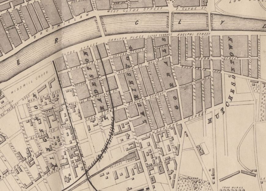
Laurieston
The land that was to be called Laurieston was feued from the trustees of Hutcheson’s Hospital to James Laurie. Ord writes:
“Laurieston, originally called Kirkcroft, was feued in 1801 by James Laurie, son of David Laurie, Timber Merchant, Jamaica Street. It is bounded on the east by Buchan Street and Portugal Street, on the west by Bridge Street and Eglinton Street, on the south by Cavendish Street, and on the north by the river Clyde. Carlton Place, which was named after the mansion of the Prince of Wales, was laid off by Mr. Laurie in 1802, and the foundation stone of the first building was laid on 4th June of that year…At the beginning of the 19th century Mr. Laurie attempted, by putting up gates, to close up the public right of way along Carlton Place, between the bridges, but the attempt failed. He also attempted, by interdict in the Sheriff Court, to prevent the proprietors of the Govan Colliery from laying their railroad across Eglinton Street for the purpose of conveying their coals to the Coal Quay at the foot of West Street. The Colliery proprietors, however, prevailed upon the Sheriff to remove the interdict on a Saturday afternoon, before shutting up his chambers, and by getting their workmen to work on Saturday night, Sunday, and Sunday night, they had their railway complete and working before Mr. Laurie could raise fresh proceedings on Monday.”
In “Glasgow – the Making of a City“, Andrew Gibb writes:
” Three hundred and seventy four properties were planned (in Lauriston) but from 1803 to 1818, there was virtually no building along the pretentiously-named Oxford, Portland, Cumberland, Norfolk and other streets. From 1818 to 1821, building activity became intense, and the development was complete by 1826, but too long a period of inactivity had permitted the intrusion of industrial activities such as brick and tile-making and the Clyde railway of the Govan Coal Company and the fine middle-class tenements of streets such as Abbotsford Place soon lost their original tenants. Despairing of the lack of social amenities, seeing their property values diminish in the face of ineffective regulations against industry, and tired of paying tolls on their daily trips to places of business in the city, the middle-class residents moved out during the second half of the century.”
The suburb, away from the centre of Glasgow, where the well-to-do could live in their beautiful Italianate Renaissance tenements breathing sweet country air, rapidly became unfashionable as the intrusion of the railways and their terminals and industry in general led to the exodus of the middle classes and the resultant sub-division of the tenements and overcrowding as the existing housing stock and any new housing was aimed at a more working class tenants.
Hutchesontown
As for Hutchesontown to the east of Gorbals, Andrew Gibb Writes:
“Tradeston and Hutchesontown, though initiated before Laurieston, never managed to attract the same level of high-status tenants, and because of poorly defined and enforced building and land use regulations, and the influence of prominent shareholders such as William Dixon, the colliery owner and ironmaster, quickly lost any early status. A Tradeston feuing plan shows clearly the dominance of canal, railways and large-scale industry in its southern sector, while the railway line running north through the development is paralleled by plots occupied by engineering and cotton works, engine and carriage sheds and workshops. Similar industrial intrusion in Hutchesontown brought rapid deterioration.“
Aileen Smart adds:
“The development of Hutchesontown, to the east of Gorbals village, began in 1790. Streets were laid out on a grid plan and pride of place along the riverside was given to Adelphi Street and Adelphi Place, named in honour of George and Thomas Hutcheson, founders of Hutchesons’ Hospital, from the Greek word ‘adelphi’ meaning ‘brothers’. Hospital Street was formed at right angles to Adelphi Street, but after the Hutchesontown Bridge was built across to the Saltmarket in 1794, Crown Street became the principal north-south thoroughfare. The river is now crossed at this point by the Albert Bridge built in 1872. The new main route south through Hutchesontown incorporates part of Hospital Street and part of Crown Street and is confusingly named Laurieston Road.
The spinning and weaving of cotton quickly became the most important of the new industries in Hutchesontown. Eleven mills were in operation around 1860, four engaged in powerloom weaving only and seven in both spinning and weaving. The two largest were Neale Thomson’s Adelphi Works between Adelphi Street and Rose (now Florence) Street, and William Higginbotham’s Wellington Mill between Govan (now Ballater) Street and Commercial Road… The Ordnance Survey map of 1859 shows, along this stretch of the river from east to west, the Springfield Print Works, Adelphi Dye Works, Clydesvale Silk and Woollen Mills, Govanhaugh Dye Works and the Albyn Cotton Works. This was the area which in the 1860s was still known as ‘Little Govan’. It was described at the time as a suburban village and precisely defined as consisting of York (Moffat) Street, Upper Govan (east part of Ballater) Street, Hayfield Street and McNeil Street.
In 1860 a second ‘industrial zone’ existed between Florence Street and Commercial Road, as far south as Old Rutherglen Road. In addition to the cotton mills and weaving factories, this area contained the Clyde Flour Mill, a starch and gum works, a hair and fur factory, a bleaching works, a chemical works, a saw mill, a biscuit factory ‘in which bickets are baked by machinery’, the Clutha Iron Works, a large foundry operated by Gourlay & Co, a smithy and a small brewery owned by Mr Rutherford on the west side of Commercial Road. The part of Hutchesontown from Florence Street west to Gorbals Main Street was occupied in the 1860s by housing with almost no industry except for the Adelphi Distillery on a two acre site close to the river banks. This was the old St Ninian’s Croft,”
Florence Street was originally Rose Street
Gorbals
I have already outlined something of the early history of the Gorbals above but we can follow the rapid growth of the parish through a series of maps. Above we saw the John McArthur Map of Gorbals in 1778.
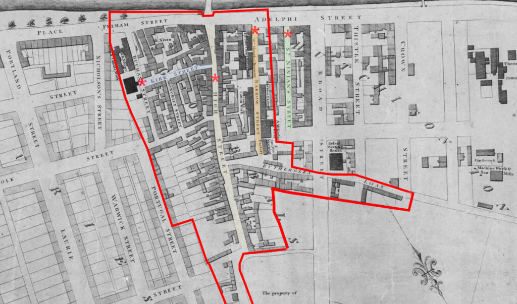
A map by Peter Fleming made in 1807 shows how much more developed the parish had become some thirty years later. I have outlined Gorbals parish in red and highlighted some of the streets of interest in our story of the Neils.
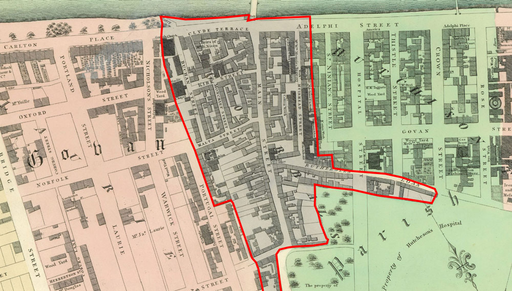
Thomas and Agnes’s first know child, Elizabeth, was born in 1819 and the next map made by Smith and Fleming in 1922 shows how much more developed Gorbals parish was around then. To the east of Gorbals parish is Hutchesontown, now already quite developed and to the west is Laurieston, only partly developed at this point.
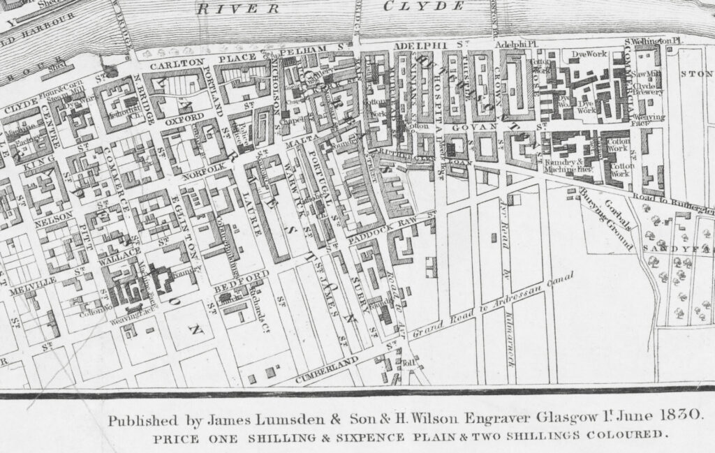
By 1830 there had been more building south of the river; mainly in Laurieston and Tradeston as the following map shows.
The growth of the area south of the river including Gorbals parish was remarkable and the Neils were part of that rapidly expanding world; Elizabeth was born in 1819, Agnes in 1824, Charles in 1826, Patrick in 1833 and John in 1836. Describing the growth of Gorbals parish, Reverend Anderson tells us in the “Old Statistical Account” written at the end of the 18th century “the people were “industrious; there are several reputable manufacturers, and a good many good operative weavers; there are 556 looms, besides a number of gunsmiths, nailers, shoemakers, tailors, wrights, cotton spinners etc.” He also predicted a big rise in population and this is indeed what happened at the start of the 19th century. At first it had seemed like Gorbals could benefit from having a residential suburb on one side of it (Laurieston) and an industrial suburb on the other side (Hutchesontown) but what actually happened, according to John Ord was:
“Wedged in the centre, the old village of Gorbals bore the brunt of the sharp rise in population and faced the task of dealing with the resultant social problems as best it could. The care of the poor was made impossible by the number of beggars and vagrants claiming to live in the Gorbals.“
The mass migration of people into Glasgow in general – but the Gorbals lands specifically – put such pressure on the authorities that they feared rioting in the city. Eric Eunson writes:
“Rioting and other lawlessness continued through several troubled years. In 1817 a report of a secret committee of both Houses of Parliament referred to Glasgow as “one of the places where treasonable practices prevail to the greatest degree”. And while this was happening more and more people poured into Glasgow seeking jobs in the factories. The position worsened and, during the autumn of 1819, cavalry and a corps of special constables were on the street every night, clearing what were described as crowds of idle populace, ready for riot. Matters came to a head on Sunday, 1st April, 1820, when the threat of rebellion became real. Hardly a man in Glasgow went to work the next day, and many began to drill in open. Actually only desultory attempts at revolt were made, chiefly by weavers from outlying districts. Eighteen men were seized, charged with high treason, and tried in Edinburgh. Andrew Hardie, an ancestor of Keir Hardy, and John Baird were executed as the ring leaders, and the others were transported. James Wilson was tried in Glasgow, and was hanged and beheaded on 30 August, in the presence of 20,000 people in front of the jail at Glasgow Green. The next decade was quieter, although the feeling for radical reform remained as strong as ever..“
Many of the new migrants to Gorbals were Irish. We have seen above that Agnes Feran was one such migrant but she must have come to Glasgow before the main wave of Irish immigration that was a result of the Great Famine – a period of starvation, disease, and emigration in Ireland that lasted from 1845 to 1852. Eunson continues:
“At first the Irish had come in small numbers, but by the ‘forties 50,000 were arriving annually, “packed like cattle into filthy boats at fourpence a piece”. The movement was at its height in the years following 1846 – that is, in the “hungry ‘forties”, when the Irish potato crop failed in two successive years. The Irish Poor Law guardians were accused of solving their problems by decanting their destitute on Glasgow and Liverpool. In December 1847, and the first three months of 1848, nearly 43,000 Irish arrived in Glasgow, few bringing anything more than the clothes they stood up in…The hostility shown to the Irish immigrant had its origin partly in unwillingness to treat sympathetically the problem created by his different religion and by his lack of schooling. The west of Scotland had plenty of other problems to deal with at the time – unemployment, deplorable housing conditions, religious controversies between Protestant sects, accommodating the Highlanders who had poured into Glasgow after the clearances had not settled down very readily in their new surroundings …Further , the situation was aggravated by religious disputes, sometimes of a violent character, among the Irish themselves..“
Ian Mitchell describes the housing conditions of Gorbals resulting from the increase in population:
“The Gorbals has medieval origins, and was at one time Glasgow’s leper colony. It grew to a population of 5,000 by 1800, and had swelled to 36,000 by the time it was annexed by Glasgow in 1846. At this time Gorbals Cross was still a cluster of buildings many dating from the seventeenth century. But the old baronial dwellings had been subdivided into festering slums and the back lands were breeding grounds of squalor. This situation worsened when Gorbals became one of the favoured settlement areas for the impoverished Irish immigrants who poured into Scotland from the 1840s.“
Eunston elaborates:
“Population growth in the new Gorbals suburbs was initially slow, increasing from the 1771 estimate of 3,000 to only 5,200 by 1811. However, this changed when the Hutcheson’s trustees abandoned any pretensions of exclusivity. Possibly motivated by the industrialisation of Tradeston, they feued an increasing amount of ground in Hutchesontown for the development of mills and factories from around 1820 onwards. New tenements erected in the area looked externally similar to the early streets, but by the 1840s contained smaller flats to cater for working rather than middle class tenants. Building projects proliferated, and the combined population of greater Gorbals had reached 54,000 by 1854. Many of the newcomers were immigrants from Ireland fleeing the famine caused by potato blight in the 1840s. Others were Highlanders cleared from their crofts by landowners who could make more money from sheep farming than letting land. But whatever their origins, the poorest of these refugees were crammed into the ancient tumble-down streets of the old Gorbals village and slums in the east end of Glasgow. When the City Improvement Trust destroyed the village and other slums in the city centre in the 1870s, some 30,000 people were evicted.“
Gerald Blaikie’s web site has a useful section where he describes the development of the Gorbals District and the later district of Hutchesontown.
By the 1870’s the solution to this grim housing situation was to be a mass demolition of the slums and the building of new tenements. That was to be in the future though; for the moment the urban conditions remained challenging.
All of these developments took place around the Neils of Gorbals and Hutchesontown but in the earliest part of the 1800s Glasgow was not as massively industrialised as it was to be by the middle of the 1800s. I consider some of the issues of health, education and employment elsewhere on this web site; for the moment I return to where the earliest of our known Neil ancestors actually lived in the Gorbals and Hutchesontown.
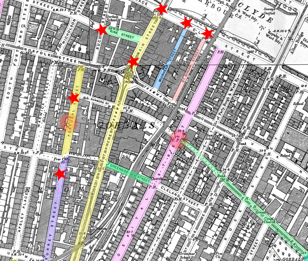
Where They Lived – Principal Streets
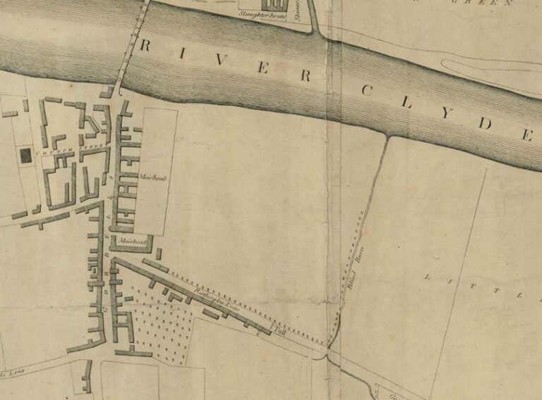
As the area grew, some of the streets changed their names; this can be seen by comparing the series of maps above. The old St Ninian’s Croft becomes St. Ninian’s Street, Broad Street became Hospital Street. Narrow Street (previously known as Warm Water Street) become Muirhead Street, so-named after Robert Muirhead the bailie of the town in 1798; it would change its name again later to Inverkip Street. This was the boundary between Gorbals and Hutchesontown. High Street became Main Street. The street running eastwards from the end of Norfolk Street up to Main Street was given a name on maps – Malta Street. Hugh Macintosh says that it was “at first called Malt Street, from the circumstance that from time immemorial it had been inhabited by maltmen, who made malt and brewed ale” and so on.
All the events surrounding the children of Thomas Neill and Agnes Feran take place within quite a small area of Glasgow, south of the river, in the Gorbals district. St Ninian’s Street, Muirhead Street, Kirk Street and Main Street are all very close together in the heart of the Gorbals and account for most of the early events of this generation of Neils. They are marked by asterisks on the map above.
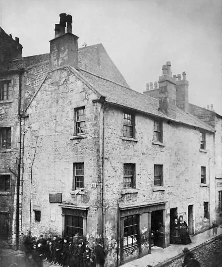
ST NINIAN’S STREET (Gorbals) Eric Eunston writes “Some time during the early fourteenth century a leper hospital was founded al Brigend. Its approximate site lay on the east side of present day Gorbals Street, near the junction with Ballater Street… it is known that the hospital was dedicated to St Ninian, and the Church gave it an adjacent strip of land which stretched from Rutherglen Road to the Clyde, known as St Ninian’s Croft. “James Muir adds “In 1794, a new Glasgow was about to arise on the south bank of the river. In Lumsden’s map of the City (1783) there is not a single house visible eastward of the Main Street of Gorbals, nor were any of the least consequence reared for ten years afterwards. But in December, 1793, the patrons of Hutchesons’ Hospital advertised that they “had laid out much money to drain the ground and defend it from the river of that level tract called St. Ninian’s Croft, etc“. Hugh Macintosh says St Ninian’s Street was “formed upon Saint Ninian’s Croft“.
Aileen Smart confirms this but adds more detail:
“The part of Hutchesontown from Florence Street (previously Rose Street) west to Gorbals Main Street was occupied in the 1860s by housing with almost no industry except for the Adelphi Distillery on a two acre site close to the river banks. This was the old St Ninian’s Croft”
According to the 1841 Census, Elizabeth Neal (sic), newly married, lived with her husband Daniel Wilkie as lodgers in the household of Mrs Brogan a “Lodging Keeper”. Mrs Brogan had nine lodgers. Because the 1841 Census does not record the relationship to the head of household it can be a bit speculative working out who was who. It seems to me though that as lodgers, Mrs Brogan has Daniel (20 and a Dyer) and Elizabeth (20 and a handloom weaver) Also there is another female handloom weaver aged 25 There is also a 25 year old “washer woman” ; this washer woman may have 2 children, aged 10 and 5 because they share the surname of McDead. The 10 year old boy is a “Taylor” as is another lodger, a 20 year old male. there are two other women, aged 25 and 20 and they are “P.L.W.s” – power loom weavers.
As mentioned above, our first recorded addresses for the family are at the 1841 Census and whilst Elizabeth lived at St Ninian, her mother, Agnes, and her sons Charles and John (Elizabeth’s brothers) are living in Muirhead Street. As yet I do not know where Agnes or Patrick were living in 1841.
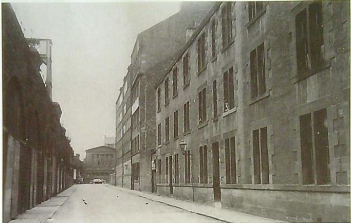
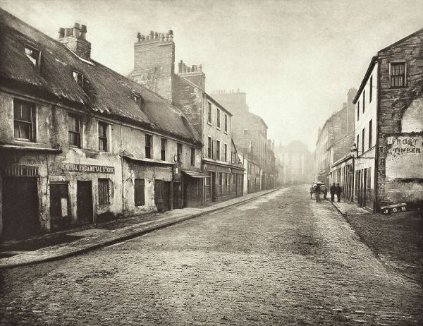
MUIRHEAD STREET (Gorbals) As mentioned above, Hugh Mackintosh says that Muirhead Street was named for Robert Muirhead, who was a Bailie in the town in 1798. It was, however, for many years better known as Warm Water Street, from a flow of waste hot water that came from a factory and ran down the side of the street into the river. On the 1801 Peter Fleming “Map of the City of Glasgow” it is called Narrow Street. This maps shows Menzies Brewery at the north west side of the street. According to Eric Eunston, Andrew Menzies had opened the Gorbals Distillery on Church (or Kirk) Street in 1786. It was the first licenced distillery in Glasgow (only the 4th in Scotland) It was demolished along with the rest of the street during its redevelopment as Oxford Street around 1867. It was founded in 1876. One web site posting records
“Over in the Gorbals was the Adelphi Distillery, built on the site of an orchard close to the banks of the Clyde in 1826, on Muirhead Street. It produced both grain and malt whiskies, the latter in four pot stills. In 1870 it was re-named the Loch Katrine Adelphi Distillery, after a merger was made with another lost Glasgow dizzy named the Loch Katrine Distillery… The Gorbals facility closed and was mothballed in 1902, but wasn’t dismantled until 1981.”
Although this states that William Menzies’ distillery on Muirhead Street was opened in 1826, it seems like there was a previous building on the site because the 1807 Peter Fleming map clearly shows Wm. Menzies Brewery. Perhaps it was the site of a brewery before it became a distillery.
The 1807 map also shows a “Flour, Corn and Barley Mill”, “A McKerlie’s Cotton Work”, “Cook’s Cotton Work”, Smith’s Machine Factory” and another machine factory” where the owner is not named. Elsewhere I have examined the residents of Muirhead street at the 1841 Census in greater detail but here I will just mention some details. The street contained 96 households though it is not clear how many houses were built and/or occupied at that time. Of the 508 people, 374 were born in Scotland (74.80%), 115 were born in Ireland (23.00%), 11 were born in England (2.20%) and for 8 no information was recorded (1.60%) 245 of those born in Scotland were born in Lanarkshire (48.23%). Rather unexpectedly the number of males and females was exactly the same – 254 of each. Although there had already been some migrants from Ireland, the 1841 Census was taken before the period of greatest migration of Irish following the Irish Potato Famine that is usually understood as running between 1845 and 1852. Among the Irish-born residents of the street, there were slightly more women than men.
The following photograph of Muirhead Street is taken from Gerry Blaikie’s web site:
KIRK STREET (Gorbals) was also known as Church Street and it originally ran between Main Street (later Gorbals Street) and Buchan Street. It was demolished during its redevelopment as the eastern part of Oxford Street around 1867. Sarah Cassidy’s parents lived at 11 Kirk Street at the 1871 Census.
MAIN STREET (Gorbals) The next time we find this family is at the 1851 Census and it seems as if Agnes and Thomas are both dead. Three of their children are living in the same household at 85 Main Street, Gorbals. This is the household of Daniel Wilkie who had married Elizabeth Neal or McNeil. Since the previous census they have had three children of their own; William, James and Elizabeth, aged 10, 4 and 2 respectively. Aso in the household is Elizabeth’s, sister, Agnes and brother, John. Daniel is a journeyman dyer and John McNeil (sic) is an apprentice tobacco spinner. Agnes is a steam loom weaver. There are three other people in the household, all lodgers and all boot and shoemakers, one of which is also a McNeil though whether he is a relation or not is questionable. Also at 85 Main Street (but in a different household) at the 1851 Census is a Charles McNeil who I understand to be the child of Thomas Neil and Agnes Feren. He lives with his wife, Elizabeth and their 1 year old daughter Elizabeth. The child was born in Glasgow but the mother is Irish. So far I have not been able to find their marriage or the birth of Elizabeth.
Main Street continues to be a stronghold for the Neils after this and Charles’s usual address was given as 27 Main Street, Gorbals at the time of his death on 21 December 1858. He died, aged 37, of “burns from his clothing taking fire”. His wife, Elizabeth, was the informant. I do not yet know what became of his family after this.
As regards Agnes, I believe she was the sponsor at the baptism of her sister, Elizabeth’s, daughter, also named Elizabeth at her baptism at the church of St John the Evangelist in Portugal Street, Glasgow on 30 January 1867; an Agnes McNeil is listed as the sponsor at the baptism of Elizabeth Wilkie. However, there is no address associated with this event.
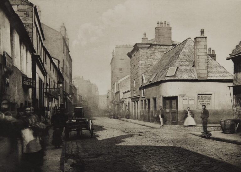
Later there are households a bit further away such as Surrey Street and Hallside Street. It is noticeable that sections of the family live variously at numbers 27, 54, 85, 135, 137 and 151 Main Street. With births it is not always clear whose household the place of birth belonged to; sometimes a child – particularly a first child – would be born in the maternal grandparent’s house, for example.
It should also be remembered that rent was a major proportion of income for the average family and taking in lodgers or downsizing were strategies to manage tight finances. The boom-and-bust nature of the emerging industrial capitalism meant that a worker could go from being relatively well off to starving quite easily; the fortunes of the weavers were a good example of this where the aristocracy of labour ended up impoverished. The fortunes of trade and the waxing and waning of family numbers also meant that families could move quite often. It may even be that sections of families might swap flats between each other in order to adjust to their changing conditions. Moving house was simpler then too, when people owned very few possessions and everyone either was or knew a carter who could help them “flit” in an afternoon.
ERROLL STREET (Gorbals) As regards, Elizabeth McNeil or Wilkie, I do not know where she was at the taking of the 1861 Census but her husband must have pre-deceased her because we find her at the 1871 Census living at 28 Erroll Street, Gorbals; she lives with her new husband, William Johnstone, a cabinet maker who was born in Dundee. They are both said to be aged 50. It was at this address that she died of bronchitis on 10 December 1872. I have not been able to find out more about Erroll Street from the usual sources but the present Errol Gardens is just north of Cumberland Street.
SURREY STREET (Gorbals) The fist mention we have of Surrey Street is in 1879. John Neil and Sarah Cassidy and their family were still living on Main Street (no 135) at the birth of their child, Charles on 21 August 1876 but by the time of their next (and last) child, Mary, on 28 March 1879 they are living at 4 Surrey Street. At the 1881 Census they are still there and their daughter Lizzie gave this as her usual residence at her marriage to John Carruthers in 1885. John actually died at 28 Hallside Street on 25 Feb 1889 aged 52 but by the 1891 Census Sarah and her children, Tom, Charles and Mary, her grand-daughter, Sarah Henderson and her mother and brother are all still living at 4 Surrey Street suggesting that perhaps Hallside Street was not John’s usual residence when he died. At the 1901 Census Sarah, aged 61, lived with her son Charles and his wife at 220c Main Street. She died 24 August 1916 at 167 Renfrew Road – the address of the Govan Combination Parochial Buildings, which included a hospital and a poorhouse. Her former residence is given as 4 Surrey Street.
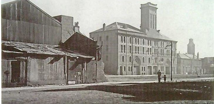
Surrey Street James Brown’s furniture factory from “The Gorbals: An Illustrated History”, Eric Eunson
1865 OS Map Lanarkshire – Section Showing Gorbals
Where They Lived – Timeline
As I do not have any address at all for Thomas Neill and only one for Agnes Feran; most of the information about where they lived is derived from the records of their children. The children were born in 1819 (Elizabeth), 1824 (Agnes), 1826 (Charles), 1833 (Patrick) and 1836 (John). There are notable gaps between the birth dates of these children that are, as yet, unexplained and there is the possibility that other children might emerge in the future. I have the baptismal records (St Andrew’s Cathedral, Glasgow) of the last two of these children but none before. Census returns state that all the children were born in Glasgow, but an open mind is required given the lack of baptismal records for them. A working hypothesis could be that the family were living in Glasgow from at least 1819. I know that Agnes Feran was born in Ireland from the 1841 Census, but I have no knowledge of Thomas Neill as he is not listed in any census I have yet found. It is only at the 1841 Census (taken on 6 June 1841) that specific addresses appear. Elizabeth and her husband Daniel (they married the previous year) are living at St Ninian, Gorbals (presumably St Ninian Street) in what would appear to be a lodging house. There are a couple of oddities in this census return in that Elizabeth is said to be Elizabeth Neal not Elizabeth Wilkie and she is said to have been born in Ireland. I look at this in more detail here. Elizabeth’s mother and two of her brothers, Agnes Feren, Charles McNeil and John McNeil are found at the same census living nearby at Muirhead Street, Gorbals.
Ten years later – at the 1851 Census – John is living at 85 Main Street, Gorbals with his sister, Agnes in the household of their sister, Elizabeth, and her husband Daniel Wilkie, and their children. Also at that address, but in another household, is their brother Charles who loves with his 23 year-old wife and 1 year-old daughter, both named Elizabeth. Charles died in 1858 from “burns from his clothing taking fire” and his usual residence was given as 27 Main Street, Gorbals.
John married Sarah Cassidy 15 Oct 1860 and they both gave their usual addresses as 54 Main Street, Glasgow. They are still there at the 1861 Census and it is clear that this is the family household of Sarah’s parents. The Cassidy family probably moved from Ireland to Eaglesham in Renfrewshire between 1845 and 1851 and moved from Eaglesham to Glasgow between 1851 and 1861. It is worth noting that another of the lodgers in the Cassidy household is a James Wilkie (John’s sister, Elizabeth had married a Wilkie) but I have not made any connection here yet.
John’s and Sarah’s first child, John, was born on 9 Apr 1862 at 11 Kirk Street, Gorbals which was then the Cassidy household. Thereafter they had their own household at 135 Main Street, Gorbals where their next children were born (Agnes on 3 Jul 1863, Ann on 3 Apr 1865, Elizabeth on 18 Jan 1867 and Sarah on 5 Aug 1869).
The family then seem to make a number of moves as the 1871 Census, taken on 2 April 1871. says that they live at 137 Main Street and this is the address given at the birth of their next child, Mary, born 5 May 1871 at 137 Main Street. At the birth of their next child, Thomas, on 28 Dec 1872 it was recorded that he was born at number 135 Main Street, their old address. 135 Main Street remains the place of birth of their next two children; James, born 2 Dec 1874, Charles, born 21 August 1876. Their last child, Mary (the second of that name) was born 28 Mar 1879 at 14 Surrey Street, Gorbals. Thereafter the family are found at this address at the following census taken on 5 April 1885. John’s daughter, Lizzie, married 8 April 1885 and gave her usual address as 4 Surrey Street so we can assume that this is still the family home.
The family may have moved to 28 Hallside Street by 1889 as this is the usual address given by his daughter, Sarah, at her marriage to William Stalker on 25 Jan 1889. On 25 February 1889 this address was also where John Neil died.
By April 1891 some remnants of both the Neils and the Cassidys are living at 4 Surrey Street as Sarah is a widow living with her sons, Tom and Charles, and her daughter, Mary, as well as her mother, Biddy Cassidy, her brother, Pat Cassidy, and her niece, Sarah Henderson.
I have a bit of a gap with John’s sister, Elizabeth, from the death of her first husband, Daniel Wilkie between 1851-1871 but when she died on 10 Dec 1872 it is shown that she had remarried to a William Johnstone and her usual residence is given as 28 Errol Street in the registration district of Hutchesontown, Glasgow
At the 1901 Census Sarah Neil or Cassidy is found living with her son, Charles, aged 24 and a coal merchant, and his wife, Annie aged 21. They live at 220c Main Street. Thereafter I lose Sarah and only find her again at her death on 24 August 1916 aged 76. She dies at the Royal Infirmary at 167 Renfrew Street and her “former residence” is given as 4 Surrey Street.
Of John and Sarah’s other children that I have found in the censuses, John Lived at 21 Salisbury Street in 1901 and 6 Eglinton Lane, Gorbals in 1911. Lizzie Neil (now Carruthers) is living with her husband, John, at 4 Surrey Street in both 1901 and 1911. Sarah Neil lives with her first husband, William Carruthers, at 120 Thistle Street in 1901 and 2nd husband, Thomas Mullen at 10 Court Street, Dundee in 1911. Thomas lives at 4 Surrey Street in 1921. As noted above, Charles lives with his wife and his mother at 220c Main Street in 1911 and by 1921 he lives at 130C Saltmarket with his wife, Annie, and their adopted son, Charles. Mary is found in 1901 living with her her husband, Patrick O’Hara, in hs family’s household at 146 Rutherglen Loan but by 1911 they have their own hone where they live with their four children at 15 Carrick Street, Blytheswood.
Sources
Books
Eunson, E. (1996) The Gorbals: An Illustrated History. Catrine: Richard Stenlake Publishing.
Gibb, A. (1983) Glasgow: The Making of a City. London: Croom Helm (Croom Helm historical geography series).
Moore, J. N. (2015) Glasgow: Mapping the City. Edinburgh: Birlinn in association with the National Library of Scotland and University of Glasgow Library.
Muir, J. (2020) Glasgow Streets and Places: Notes and Memoranda by the Late James Muir, C. A. Forgotten Books.
Ord, J. (1919) The Story of the Barony of Gorbals. Paisley: Alexander Gardner.
Sinclair, J. (1793) The Statistical Account of Scotland. Edinburgh: William Creech (Volume V: Gorbals, Lanark).
Smart, A. (2023) Villages of Glasgow Vol 2: South of the Clyde. Edinburgh: John Donald Publishers
Maps
“Plan of the City of Glasgow” John McArthur (1778)
“Map of the City of Glasgow” Peter Fleming (1807)
“Map of the City of Glasgow” Smith & Fleming (1822) – detail
“City of Glasgow and suburbs, corrected up to 1830” (1830) James Lumsden & Son & H Wilson
“Plan of the City of Glasgow” Allan & Ferguson (1847) detail of Distribution of the Gorbals Lands and Their Development
Photographs
- St Ninian’s Street from “The Gorbals: An Illustrated History” Eric Eunson
- Muirhead Street, Gorbals, Glasgow
- Main Street Gorbals Looking North – Thomas Annan photograph 1868 – 1877
- Main Street Gorbals Looking South– Thomas Annan photograph 1868 – 1877
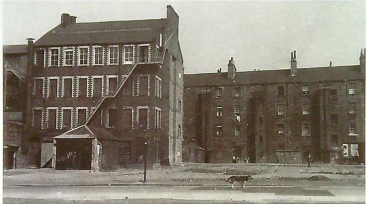
- Surrey Street facade of Grain Mills from “The Gorbals: An Illustrated History” Eric Eunson
- Surrey Street James Brown’s furniture factory from “The Gorbals: An Illustrated History”, Eric Eunson
Web Sites
The Gorbals: A New Glasgow Suburb, “Pat’s Guide Glasgow West End “ Ian R Mitchell